At https://phys.org/print425033494.html … in the first paragraph we learn the Mackenzie Trough westwards, including the Yukon part of the continental shelf system, is being researched in order to understand glaciation in north west Canada during the Late Glacial Maximum (and the events that brought it to an end). We are told, 'scientists have had to speculate on the extent and timing of glaciation because they've never been out there with equipment to collect data'. In other words, it is an assumption that an ice sheet covered western Canada during the last Ice Age (or at least between 30,000 and 15,000 BC). Alaska is reported to have been largely ice free – but how far eastwards did the lack of an ice sheet stretch?
Glacial history, from a geologists perspective, has direct influence on the strength and properties of sea bed sediments (how a warming climate may affect the region, and beyond). The current expedition is using sonar instruments to recognise where sediments were removed by glacial advance and retraction. Sediment cores are part of the process of research. This process is thought to have created the Mackenzie Trough, a large scar 100m deep and 10s of km wide gouged out over 100km in length across the continental shelf area. When the glaciers retracted it lef behind massive deposits of mud, sand and gravel mixture (a typical till deposit)and melt waters created a well layered sediment bed (like a layer cake) …
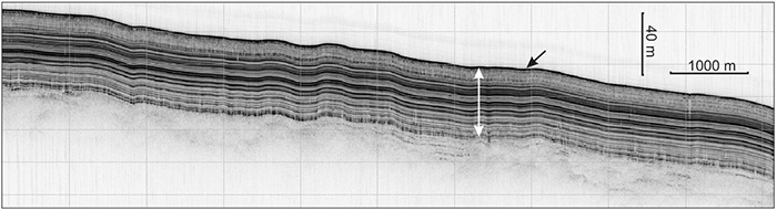 … the deposits are around 20 to 40m deep, although depths of 80m also occur on the odd occasion. Is it possible there was no glaciation (20,000 years ago)? Was the melt water (and the sediment bed) left behind by an ice sheet collapsing on the Canadian Shield, using the Mackenzie River to disgorge large amounts of excess water (as is known to have occurred with the Mississippi). This would be necessary if humans had crossed the Arctic Ocean directly to western Canada (as well as Alaska) inorder to make use of the Mackenzie River as a route south. There is of course no proof this happened – apart from knowing that people in boats lived in northern Siberia 20,000 plus years ago. According to mainstream this is impossible as a massive ice sheet covered most of northern North America – but did it? Any evidence of human activity would have been lost in the melt water flooding – although Velikovsky claimed human tools were found in Alaskan much deposits. What is underneath the sediment is perhaps more interesting than the sediment itself – unless the discovery of shells or other once living organisms are found in the sediment and can be used to extract a C14 date.